Dix River
Dix River VPA, Boyle County
by John Kirkland
(250 CFS, 2.5 feet on 4/13/14, current conditions here. Herrington was at 736 feet–pay attention to this number as well here)
4/13/2014: I found myself with a few hours to go fishing this afternoon, so I hit the computer and started going through all the spots I’ve been thinking about visiting. After my fruitless white bass trek to the Salt River a few weeks ago, I thought I’d try to go where there had been confirmed reports of white bass running. The KDFWR site had run a story about the white bass, and mentioned the Dix River headwaters above Lake Herrington, and also mentioned a VPA (Voluntary Public Access) property in Boyle County. I set out for the 45 minute trip from my house on the south side of Lexington, hoping to catch up with the white bass run.
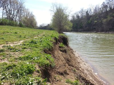
The VPA is located at the end of Rankin Road, which is about halfway between Danville and Lancaster off Highway 52–turn north onto Rankin, and follow it to the end. Parking is along the right of way, and there was a fairly ample amount of graveled and cleared right of way. Park, then walk through the marked gate at the end of the road. Getting from the road to the VPA, you will cross about 20 feet of somewhat rough and rocky ground. This could be troublesome for mobility-impaired visitors. After that, the area is a long, flat, open field, with a steep dirt/clay bank dropping to the water. There are a few points where someone could ramble down to the water, but not many, in this area (the “front”).
At first I was a little underwhelmed–it looked like any river bank on any impounded river. I arrived about 3:30 pm, and some folks said that the bass had run earlier in the day, but the action dropped off. A few people reported catching a few various fish.The VPA is long and narrow, though, and there is fair access to the river upstream. I began walking upstream, fishing a rooster tail, then a big white grub.
There were quite a few people there, but the area is pretty stretched out, and I never felt crowded. A nice young guy with a slight European accent started talking to me, and he showed me what he was using, and how and when things worked, generally. Nice to have somebody with local experience to consult. He was throwing a 1-inch white curly-tail grub on maybe 1/8 ounce jig head. He said the white bass attack it if they are running, but also the hybrid stripers will hit. I asked him if there was a riffle or shallow area nearby, and he said to keep walking upstream, and I’d see the riffle.
It is a bit of a walk-about a half mile or so–until the river topography changes. The bottom opens up and if you do a little scrambling, and can accept getting your feet a little wet, the riffle and subsequent wild-ish river are accessible. Today, there was a nice flow, with a few Class I rapids. There was 12-18 inches of water, with a pretty fair current, moving over the shoals and spots where you could cross.
I managed to land a 10-11 inch largemouth just below the riffle, and kept noticing big buffalo carp running and feeding up stream at this point. The nice fellow I met earlier had caught two 20-inch buffalo, maybe 5-6 pounds each, and had them on a stringer. He said his cats love to eat them. He said all you have to do is drift a grub on a big hook down stream where they are congregated, and they will hit. I thought I’d give it a shot. I sent a 2-inch grub on a half ounce head down the center of the rapid water, and sure enough, a fish hit. He fought for a few seconds, the got away. I did it again, and this time, I really hooked him. A BIG one, 15-20 pounds, at least. I fought him for at least 10 minutes, but he had managed to wrap a boulder or log. I’d give him slack, the line would head upstream, I’d reel, and he would surface briefly (25-30 inches, maybe 12-15 inch diameter body). After a while, it was obvious that I wouldn’t be landing him. Too much current, too many places to hang up, and I was throwing 12-lb braided test on a light spinning rod. I wasn’t equipped to land a big fish. I broke off the line, and headed home.
Dix River VPA is a great resource, and offers a lot of potential. Access to a river like the Dix is somewhat hard to come by. The setting is beautiful–palisade walls and rural scenery.
UPDATE 6/22/14: The field that stretches along the river/lake was unmowed and heavily covered in vegetation. The path disappears after the first fifty yards or so, making it difficult to reach the riffle upstream. If you are headed there in the summer, wear pants and boots, and watch for snakes…
Let us know what you know about Dix River VPA in the comments–we appreciate it!
Dix River VPA, facing downstream toward Herrington Lake

Dix River
Dix River, Below Lake Herrington
by John Kirkland
August 2009
After weeks of rain, a short dry spell finally allowed the water levels of the Kentucky River and its tributary, the Dix River, to fall closer to normal. I’ve been waiting on the water to try paddling up the Dix, which can only be reached from the Kentucky River (there is no public access to the Dix River below the Lake Herrington Dam). Information about how to get there, and where to launch is spotty at best, but after some searching, talking to locals, and hard paddling, I found the Dix River.
The only public ramp is easy to miss. Take 29 from Wilmore, and when you get almost to Highbridge (the structure, not the water company), turn right on Lock 7 Road. Go to the bottom of the hill; there is a sharp bend in the road there. Instead of going around the bend, go straight through what appears to be a gate, and on the immediate left there is clearing and a sign indicating the boat ramp. The ramp is narrow, and cut directly into the clay bank. Park in the grass, and pay the launch fee in the blue box ($2 for canoes and kayaks, $4 for trailered boats [2009 prices]). Kayakers beware: I found out the hard way that the concrete ramp drops right off into four feet of water there (most ramps have gravel or rocks shoring up the sides. Not this one.)
After launching, I began paddling upstream toward the mouth of the river. (A note of caution: if you weren’t already aware, the Kentucky River is a muddy, filthy, trash filled river. The surrounding scenery is gorgeous, however.) After rounding the bend, Highbridge comes in sight. At one point, the bridge was the highest railway span in the world. Paddle past the bridge, and the mouth of the river is on the right.
It is a pretty good hike up the river if you are paddling it. From the ramp, the mouth of the river is almost a mile. The to the dam is another three miles upstream. I paddled my kayak for a solid hour to get to just below the dam, where I started fishing. A motor boat could make the trip faster, but the river is filled with submerged timber, rocks, and the occasional stump or outcropping. A boat with a draft of more than 3-4” risks running into submerged objects or whacking a prop on something solid, so go slow and watch carefully.
This is supposed to be a fishing report—I fished a solid two hours, hooked one unknown fish that got away quickly, and one bluegill slightly larger than the roostertail I was throwing. To be fair, others on the water reported the same results. I did, however, see lots and lots of trout. I saw a few monster (20-plus inches) trout surfacing to feed. I’m really more of a bass fisherman, apparently.
As you paddle up the Dix, you pass a small waterfall on the right. There is a sign posted there noting the fishing restrictions in place—artificial lures and flies only, no organic or live bait allowed (or even possessed). Also noticeable is the clarity of the water; the muddy, trashy water of the Kentucky is replaced by cold, clear, constantly moving water released from the dam above. In the hot, muggy, 90 degree August afternoon, the cool water interacts with the hot air, creating a foggy mist that floats over the river. It is beautiful, and quiet, except for the sounds of the dam and power plant upstream.
From the bottom of the dam, I started drifting downstream, fishing as I went. Trout are visible in the breaks behind the large rocks that tumble off the limestone palisades above. A friend of mine mentioned using a peach-colored freshwater shrimp pattern to entice the brown trout there. I found that a black Mepps Fury, chartreuse roostertail, pink roostertail, rainbow creek minnow, and various diving and floating crankbaits have no effect on these fish at all. I’ll be certain to talk to some experienced trout anglers before I try that again.
The Dix River isn’t easy to get to. It is a pretty serious paddle for a casual afternoon of fishing. It is a beautiful place, primarily populated with other paddlers (I saw only two motor boats above the waterfall). I have heard and read many stories about great fishing there, but I hit it on a day that just wasn’t happening. I may try it again in another season, like autumn. I’ll update this report if I get back there and have different luck.