North Elkhorn
Kayaking the North Elkhorn
by John Kirkland
August 28, 2011
(Run at 7 CFS, 3.75 feet according to USGS. Ideal would be probably 4+feet, 20+CFS. USGS Gauge HERE)
There is a section of the North Elkhorn, between Robinson Dam and Galloway Pike, that I’ve been staring at on Google maps for a couple of years. Very little is written about this part of the creek. Vague descriptions here and there say that the North Elkhorn is runable in Winter and Spring from Georgetown to the Forks. I’ve waded down from Robinson maybe a half mile before, where the creek is deep and wide. Putting a kayak in at Robinson and out at Galloway looks possible from the satellite, but how many CFS are needed to get a decent draft was totally unknown. This section is remote-ish. Casually looking at the map, I estimated 3.5 to 4 miles in length. A more careful measurement later revealed that the distance is actually 5.7 miles.
A friend and I decided to run it yesterday (Aug. 28). Weather was perfect: 78° and sunny. We decided to check out the flow at the take-out (Galloway) first to get an idea of whether this was even possible. There appeared to be about 18 inches of water and a decent flow there. The stream gauge in Georgetown read a very low 7 (seven) CFS at 3.75 feet. We dropped a vehicle, and headed back to Robinson.
We put-in below the pool of the dam, and started downstream. I fished with a white roostertail as we went, managing to land one decent 12-inch white crappie in the first pool past Robinson. It was getting late in the day for fishing, so I didn’t expect much. This trip was primarily about scouting a section of creek new to us.
The first pool is fairly long—about 1/3 of a mile. At the end is a pile of old iron rails and tile pipe; maybe an old bridge. We grounded on the rocks here, and had to pull the kayaks over the chute. This was the first of many times we would have to pull the boats over shallow water.
The next half mile is a very pretty shaded stretch, following a bend, with numerous shoals of shell banks, gravel, and river rock. This stretch ends at an old, washed out bridge, one end cut off with a bow washed out of the clay bank ten feet wide. Just beyond, two giant sycamores, upended in a recent flood, make a chute down the middle.
The creek meanders through the country, over shoals and open stretches for another mile or so. Here, we were surprised to see three horses come down the banks and into the water. Further down, a large buck crossed the stream. A red tail hawk was working the valley ahead of us.
Turning the second bend in the route, the geology changed. A sheer limestone cliff lined the left side, and the water sped up. We came to the conclusion that another six inches of water in the creek would be perfect. This area was beautiful–cliff, smooth, stepped bedrock bottom, green forest gently ascending on the right side, in a curve.
This was followed by a series of riffles, with nice 50-yard wide, deep clear pools between. Maybe three or four of these pools, then the country opened up again.
At a shallow riffle, we stopped, and checked the GPS. Three hours had passed, and we though we must be almost through the course. In fact, we were only halfway there. It was a great way to spend a day, but we had only brought food and water for 3-4 hours. We decided that we should pick up the pace, in case we ran into trouble or an unexpected portage.
The route juts east, then curves north in a long bow for a couple of miles after this. Numerous times, in this stretch, we were out of the kayaks, pulling over shallow riffles, wide shallow gravel beds, piles of rocks, and all kinds of other obstacles. A real work out. We hit a long (1/3 mile), wide, deep pool, and paddled quietly, making up distance with little effort. The end of this pool was a surprisingly runable class I chute and slide, followed by a hard left class I, then a bit further down, a nice slide. With a bit more water, this would have been a great ride in a canoe or yak. It was fun as it was, though.
Turning west, again we ran a series of shallows and nice runs in the shade. Finally, at 4 PM, we rounded a bend and saw the Galloway Bridges. We beached left, short of the old bridge, and followed the easy grade up to the old bridge, where we crossed to the truck dropped earlier. At six hours, this was more trip than we had bargained for, but it was fun, the weather was great, and the scenery beautiful. The last half of the route was FILLED with fish–I had stopped trying to catch them, though, to make up time. We decided that we would like to try it again with more water, later in the year.
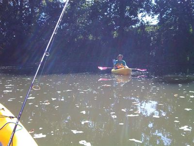
Andrew on the Elkhorn